Maps / Charts
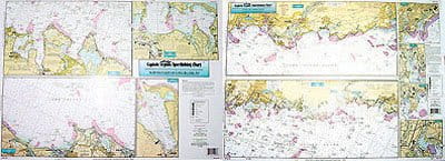
Captain Seagull's Coast of CT and North Shore of Long Island NY Inshore Nautical Chart
Item ID: 5875
$20.99
Select Model:
In Stock
There are no reviews for Captain Seagull's Coast of CT and North Shore of Long Island NY Inshore Nautical Chart yet.
Captain Seagull's Coast of CT and North Shore of Long Island NY Inshore Nautical Chart is a an inshore chart 1-2 miles off the coast detailing the bays. Chart is 19 x 26 inches, double sided, and laminated.
Detailing the bays, covers western half of coast of Connecticut. West Haven, CT to NY border; North Coast of Long Island, NY . All charts include GPS coordinates, wrecks, reefs, shoals, fishing areas, amenities and restrictions.
Captain Seagull's Coast of CT and North Shore of Long Island NY Inshore Nautical Chart - Model # NLI106
Details:
Color - Brown/White
Gender - Male